
North Yungas Road (Death Road)
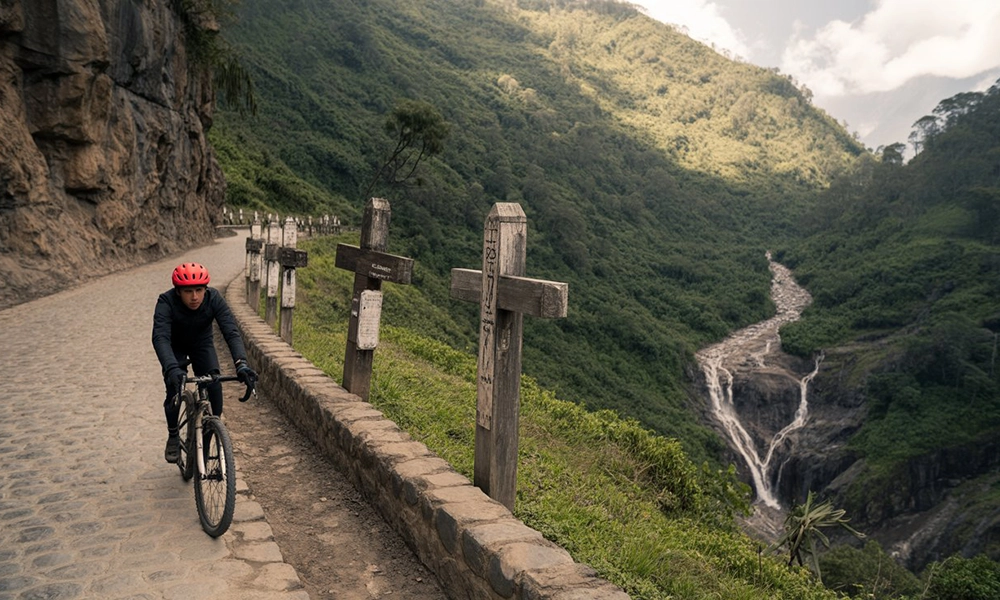
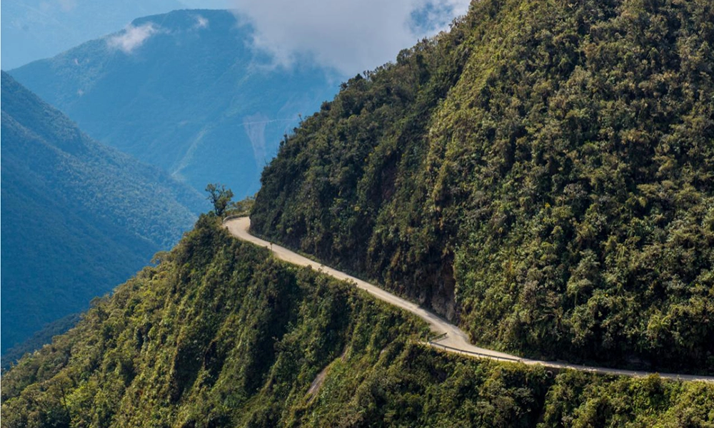
The North Yungas Road (also known as Yungas Road or the infamous “Death Road”) is one of Bolivia’s most intense adventure experiences. Its fame began when it was the main route between La Paz and the Yungas region: a narrow road, often shrouded in fog, rain, landslides, and precipices without guardrails in many sections. Today, after the construction of a more modern alternative highway, the “old road” has become an icon of downhill mountain biking (and also an attractive route for motorcycling, hiking, and photography).
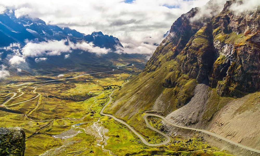
What makes this route unique is not just the adrenaline rush: it’s the dramatic change in landscapes in just a few hours, descending from the cold highlands to the lush green of the Yungas cloud forest.
📍 Where exactly is it located, and what is the route like?
The North Yungas Road connects the area around La Paz with the Yungas region. The classic tourist experience involves a downhill bike ride from the La Cumbre sector (highlands) to Yolosa/Coroico (lowlands), with a total descent of approximately 3,500 meters and a length of about 64 kilometers (depending on the section and operator).
Why are there terms like “old route” and “new route”?
- The old route is the one that gained notoriety for its danger (narrow, gravel, and steep drops).
- Since 2006, a safer alternative route has been in place, with improvements such as paving, drainage, and guardrails. This has reduced vehicular traffic on the old section, leaving it primarily for tourism and occasional local use.
🕰️ History (why it became legendary)
- It was built in the 20th century (in the 1930s) to connect La Paz with the north and areas closer to the Amazon rainforest; Part of the work is associated with Paraguayan prisoners of war after the Chaco War, according to historical accounts of the route itself.
- The nickname “Death Road” became popular due to its history of accidents when it was the main road. In the 1990s, estimates of 200–300 deaths annually were cited during the most critical periods (the exact figure varies depending on the source, but the range is repeated in several references).
- Today, the route remains demanding, but tourist use is done with guides, support vehicles, and protocols (if you choose a reputable operator).
🧭 What is the experience like? (from snow to jungle in one day)
One of the “wow moments” is the change in ecosystems:
1) High zone (Altiplano – La Cumbre)
- Cold, windy, low clouds.
- Strong wind chill and high solar radiation even when it’s cloudy.
2) Mid-altitude zone (cloud forest)
- Dense fog, constant humidity.
- Vegetation with mosses, ferns, and epiphytes (a “green and wet” landscape).
3) Lowlands (Yungas: Yolosa / Coroico)
- Much warmer.
- Lush vegetation and a tropical feel.
This contrast also explains why the weather can change rapidly on the same tour.
🌿 Flora and Fauna (What You’re Really Going Through)
Although most people market it as an adrenaline rush, the Death Road crosses environments linked to the Yungas, and according to guides and local conservation documents, you can pass through areas with ecological gradients ranging from high mountains to humid mountain forests (cloud forest and Yungas).
Flora (according to altitude)
- High altitude: ichu/high-altitude grass, low-lying vegetation resistant to the cold.
- Cloud forest: mosses, ferns, bromeliads, and humid vegetation.
- Yungas: more tropical trees and plants, lianas, and dense vegetation.
Wildlife (possible, not guaranteed on a 1-day tour)
- Cloud forest birds (hummingbirds and colorful birds; sightings vary by time of day and weather).
- Butterflies and other large insects in warm areas.
- With luck, small mammals; generally, more wildlife is seen if you stay in Coroico and take separate guided hikes.
🌦️ Weather and Best Time to Go
Recommended Season: Dry (approx. May to October)
Typically features:
- Less rain and mud.
- Greater visibility.
- Lower probability of landslides compared to the wet season.
Rainy Season (approx. November to March)
- There may be more dense fog, rain, and muddy sections.
- Operators may adjust routes/pace for safety reasons.
🚴 Star Activity: Downhill Biking (the real-life experience)
Most tours include:
- Early pickup in La Paz
- Transfer to the starting point (La Cumbre area)
- Safety briefing + equipment
- Descent in sections (some initial sections are more paved; then gravel/curves/precipice)
- Arrival in a warm area (Yolosa/Coroico) + lunch and return
The duration of the ride varies depending on pace and stops; Many tours mention approximately 4–5 hours of riding (not including transfers).
🧤 Recommended Gear (what REALLY makes the difference)
Clothing (in layers)
- Thermal base layer (it’s cold on top).
- Lightweight windbreaker/rain jacket (fog and rain are common).
- Gloves: help with the cold and control.
- At lower altitudes: light shirt (you’ll end up sweating).
Protection and Accessories
- Full-face helmet or a proper helmet + goggles (ideal).
- Knee/elbow pads (minimum if you’re a beginner).
- Sunscreen + lip balm (high radiation at altitude).
- Small backpack with water.
Health (altitude)
The starting point is high, and your body will feel it. If you’ve just arrived in La Paz, it’s advisable to acclimatize for at least one day. (Many travelers report that this completely changes the experience).
✅ Safety: Checklist for choosing an operator (what you absolutely MUST look for)
Your safety depends more on the operator and your responsible riding than on the “myth” of the trail.
Look for:
- Sufficient guides per group (not just one guide for everyone).
- A support vehicle following the group.
- Bikes with visible maintenance (brakes, tires, suspension).
- A thorough briefing before setting off.
- Real protective gear (not just “cosmetic”).
- Good track record/reviews: there are very well-known operators in La Paz (for example, Gravity Bolivia is frequently mentioned, with a presence since the late 90s).
Golden rule:
- Don’t race for speed. Keep your distance, brake early, and prioritize control over “bravery.”
🗺️ How to get there and logistics
From La Paz (most common)
Almost everyone does it as part of a tour: transportation + bike + guides + return.
Is it possible to go independently?
Technically, yes (some people do it), but for most it’s not recommended due to:
- Changes in weather,
- return logistics,
- the need for support and real safety,
- road conditions.
🧭 Other activities to complement your trip (if you want a more complete experience)
If you don’t want it to be all about biking:
- Stay in Coroico for 1–2 nights (rest, warm weather, viewpoints).
- Cloud forest hikes (more nature and birds).
- Photo tours (fog + mountains + jungle look amazing).
💰 Reference Prices: How Much Does It Cost and What’s Usually Included
Prices vary depending on:
- Bike type (basic vs. full suspension),
- Group size,
- Meals included,
- Operator reputation.
References on platforms and travelogues show wide ranges. For example:
- Day tours are around US$90–135 in listings/experiences (varies by season and operator).
- Some tours add community fees/entrance charges (for example, a total of 50 Bolivianos is mentioned in some listings, divided into two payments of 25 Bs).
What’s usually included:
- Transportation from La Paz (round trip)
- Bicycle + helmet + protective gear (depending on the package)
- Guides + support vehicle
- Snack and/or lunch (depending on the operator)
What’s sometimes NOT included:
- Local/community fees
- Extra drinks
- Tips
🧠 Quick Guide: Who is it for and who is it NOT for?
Ideal if:
- You enjoy adventure and aren’t intimidated by heights.
- You have basic bike handling skills (braking and cornering).
- You’re willing to follow instructions without trying to be a daredevil.
Best to avoid if:
- You suffer from severe vertigo and it freezes you up.
- You don’t know how to brake properly on gravel (or you’re scared of loose stones).
- You’re experiencing severe altitude sickness that day.
❓ FAQs (Frequently Asked Questions)
1) Is it still “the most dangerous road in the world”?
Its reputation stems from when it was the main route and had many accidents. Today there’s a safer alternative road, and the old route is mainly used for adventure tourism. Even so, it’s still a real risky road, not a theme park.
2) How long does the complete tour last?
It depends on the operator, but the day is usually long (departing very early). The bike leg usually involves several hours of downhill riding; some tours mention 4–5 hours of riding.
3) Do I need MTB experience?
Not necessarily “pro,” but basic control is essential: braking well, descending smoothly, cornering, and maintaining a safe distance. If you’re a complete beginner, ask for:
a better bike (if available),
more practice during the briefing, and
to ride with a guide at the end.
4) How cold is it?
It can be very cold at the top (altitude), and hot and humid at the bottom. That’s why layering is key.
5) What happens if it rains?
There may be mud and low visibility. Reputable operators will adjust speed, stops, or even the itinerary if necessary.
6) Are there extra costs?
Sometimes yes: community fees/entrance fees (for example, listings that mention a total of 50 Bs for entrance fees).
7) Does it end in Coroico or Yolosa?
It depends on the tour. Many routes end in a lower area like Yolosa, and then you return to La Paz or connect to Coroico.
8) Can it be done without a tour?
It’s not recommended for most people due to safety and logistical reasons. With a tour, you have guides, support, and established protocols.
If you’re looking for a challenging and photogenic experience, the North Yungas Road is one of Bolivia’s most memorable adventures: a legendary descent that combines history, precipices, fog, and jungle in a single journey. Its reputation is backed by its (very dangerous) past and the fact that it remains an extreme road, although today it’s experienced in a more controlled way thanks to organized tourism and the modern alternative route.