
Isla del Sol
Isla del Sol is the most mythical and emblematic destination on Lake Titicaca in Bolivia. It’s not just the largest island on the lake; it’s a place where the Andean highlands, Aymara communities, and Inca ruins blend with a special energy. According to the Andean worldview, one of the most powerful stories of the Inca world took place here: the symbolic birth of Manco Cápac and Mama Ocllo, the founders of Cusco.
Visiting Isla del Sol is a dual journey: nature + living culture. It’s walking among ancient terraces, breathtaking viewpoints, bays of deep blue water, and trails that connect communities that still maintain a tranquil pace of life, inextricably linked to the lake.
📍 Where is Isla del Sol and why is it so important?
Isla del Sol is located within the municipality of Copacabana (La Paz, Bolivia). It is approximately… 9.6 km long, 4.6 km wide, and with an area of approximately 14.3 km², making it the largest island in Lake Titicaca.
Its importance can be understood on three levels:
- Mythical/spiritual: the “cradle” of the Inca origin in tradition.
- Historical/archaeological: the presence of roads, agricultural terraces, and ceremonial sites.
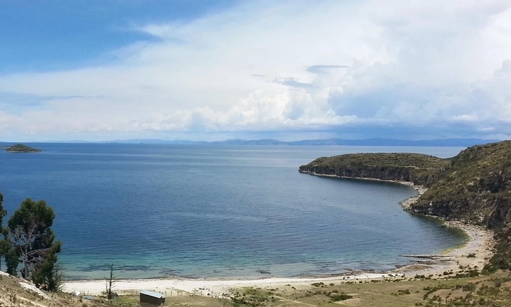
- Scenic: 360° views of Lake Titicaca, with intense light, blue water, and snow-capped mountains on the horizon (depending on the season).
🕰️ History and worldview: the “House of the Sun” on Lake Titicaca
In the Inca religion, the island was considered a sacred space, associated with the Sun and the origin of the world order. Therefore, many roads and ruins are interpreted as part of a ritual geography linked to pilgrimages, offerings, and the observation of natural cycles.
Beyond the myth, the island shows clear traces of Andean occupation: terraces, canals, and stepped platforms that demonstrate high-altitude agriculture and water management.
🧭 Main Areas and Communities
The island is typically explored in two tourist sectors (north and south), connected by trails:
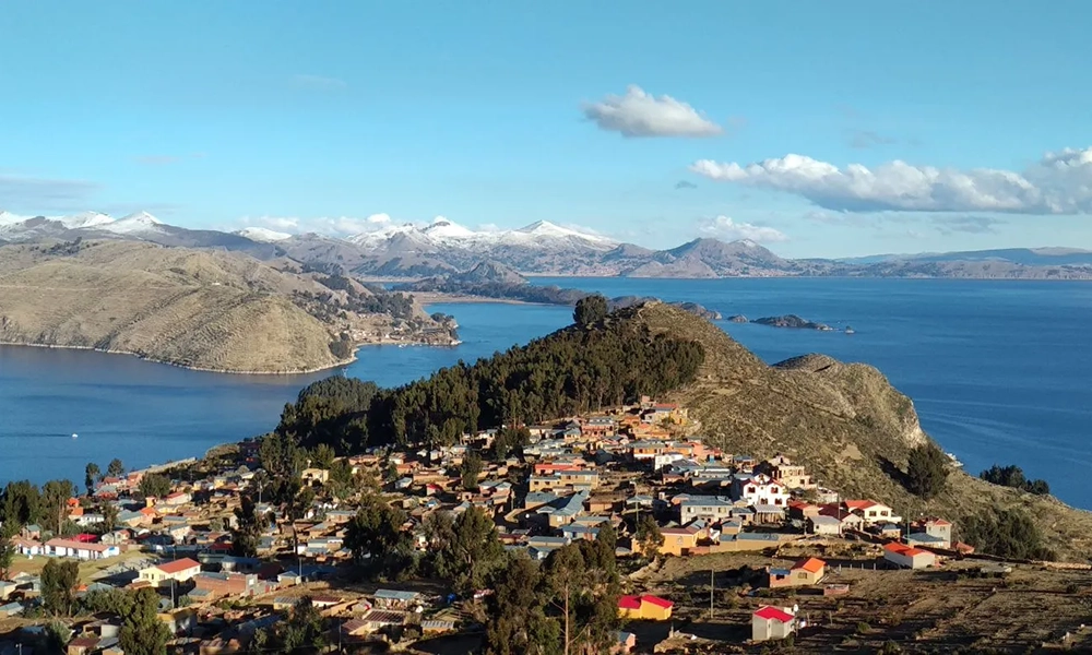
✅ South: Yumani (the most frequently used access point)
Yumani Village (typical arrival point for many boats).
Scenic trails and access to hikes towards the center/north.
It is often the starting or ending point for the transverse trek.
✅ North: Challapampa (another classic arrival point)
Connection to routes to archaeological sites in the north.
More tranquil and “rural” atmosphere.
Between the two areas are communities, cultivated fields, and pastures. The island, according to geographical descriptions, can be divided into “ecological zones” ranging from coastal cultivated fields to terraced hillsides, wetland-like grasslands, and hills with sparser vegetation.
🏛️ What to see on Isla del Sol: main attractions
1) Panoramic trek from south to north (or vice versa)
The star attraction: hiking the island’s longitudinal trail, crossing hills, viewpoints, stone walls, cultivated fields, and enjoying open views of the lake.
Realistic fact: the altitude makes the hike noticeable. It’s not technical, but it is demanding if you’re not acclimatized.
2) Archaeological Sites and Inca Ruins (depending on the route)
Among the most searched names by travelers:
- Pilkokaina (southern sector, Inca ruins near Yumani)
- Chincana (northern sector, labyrinth/ruins)
- Sacred Rock (northern sector, symbolic site)
(Exact access points may vary depending on the community and local organization.)
3) Natural Viewpoints
Each ascent offers a different vista: Lake Titicaca appears enormous, with intense blue hues and gentle shorelines. On a clear day, the landscape becomes cinematic.
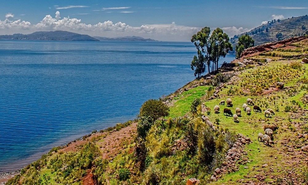
4) Terraces and Traditional Agriculture
The agricultural terraces (andenes) are part of the charm: seeing how the land is worked on an island at this altitude changes your perspective of the Altiplano.
🌿 Flora of Isla del Sol
The vegetation is typical of the Altiplano, adapted to the cold, wind, and intense radiation:
- Ichu grass and Andean grasses in high-altitude areas.
- Low-lying, hardy vegetation on the slopes.
- Traditional crops in fields and terraces (depending on the agricultural season): potatoes, quinoa, broad beans, oca, etc., referred to as terraced crops.
- Local medicinal plants (according to the community).
Don’t expect a “jungle”: here, the beauty lies in the open landscape, the texture of the soil, and the contrast with the blue of the lake.
🐦 Fauna: What animals might you see?
The fauna is perceived more as “lake life + high plateau”:
- Birds of Lake Titicaca (Andean gulls, ducks, small birds).
- Local livestock and camelids (sheep, llamas) grazing in pasture areas.
- Occasional small Andean fauna (depending on the time of day and the quietness of the area).
🌦 Climate on Isla del Sol
High Andean climate: sunny days and cold nights.
- Daytime: temperate with strong sun (the radiation is noticeable).
- Night: cold (temperature drops considerably).
- Wind: frequent, especially on hills and viewpoints.
📅 Best time to visit Isla del Sol
For hiking, photography, and clear skies, the most common recommendation is the dry season:
- April/May to October (dry, clearer skies).
- Many travelers specifically recommend May to September for more stable conditions.
During the rainy season
Rain can make trails more slippery and cloudy, although the landscape appears greener.
🚤 How to get to Isla del Sol
1) Arrive in Copacabana (Bolivia)
Copacabana is the most common base. From La Paz, there are buses/tours that cross the Strait of Tiquina and arrive in Copacabana (a route frequently used by tourists).
2) Copacabana → Isla del Sol (boat)
Access is by boat. Prices and travel times vary, but references include:
- A trip of approximately 1 hour 15 minutes and tickets of 30 Bs (one-way) according to traveler experiences.
- “Water taxis” are also described, charging around 20–30 Bs per section/area, with no fixed schedule (they depart when full).
👉 In practice, in Copacabana you go to the pier, ask about departures to Yumani (south) or Challapampa (north), and buy your ticket.
3) Getting around the island
- Options: Walking (highly recommended for experiencing the island).
- Boats/water taxis between areas if you don’t want to do the entire hike.
🧭 Activities to do (beyond the “typical tour”)
1) Cross-island trekking (main experience)
- “Epic” option: hike from Yumani (south) to Challapampa (north) or vice versa.
- Shorter option: viewpoints and ruins near the port where you disembark.
2) Landscape photography
- Sunrise and sunset: golden light, long shadows, blue water.
- Night sky: if you stay overnight, you can see a breathtaking starry sky (weather permitting).
3) Experiential Tourism (if you stay overnight on the island)
Homestays and simple local meals: a lovely way to directly support the communities.
4) Kayaking / Beach (depending on the area and operator)
In some bays, people go into the water. (Note: the water is cold; it’s not always comfortable for swimming.)
💰 Reference Prices
1) Boat Copacabana ↔ Isla del Sol
- Traveler reviews mention 30 Bs per trip (one-way) and approximately 1 hour 15 minutes.
- For internal connections, 20–30 Bs per trip in a “water taxi” is quoted (depending on the distance).
2) Entrance Fee / Community Ticket
- Several travel guides mention fees around 10 Bs (collected upon arrival, cash only).
3) Organized Tour (Full Day from La Paz or Copacabana)
- Price depends on the operator, transportation, and guide (there are “full day” tours and packages).
Practical Note: ATMs are not always available on the island, and many things are cash only. Some guides recommend bringing small bills.
✅ Key Recommendations (for a perfect trip)
- Acclimate: If you’re coming from a low altitude, spend at least one day in La Paz or Copacabana before the long hike.
- Sunscreen + sunglasses + hat: The sun is strong at high altitude.
- Water and snacks: Bring your own for long hikes.
- Small bills: For entrance fees, boats, and purchases.
- The Daily Packers Layers of clothing: Cold mornings, sunny midday, windy afternoons.
- Walk at a slow pace (the altitude is noticeable).
❓ FAQs: Frequently Asked Questions
1) How much time do I need to visit Isla del Sol?
- Full day from Copacabana: Possible if you take a short or medium hike.
- Ideally: 1 night (to walk at a leisurely pace and watch the sunset/sunrise).
2) Is the hike difficult?
It’s not technical, but it is moderate due to the altitude and the inclines. If you’re not acclimatized, it becomes challenging.
3) How much does the boat cost?
Common references include 30 Bs per trip (one-way), lasting around 1 hour and 15 minutes, although this can vary depending on the season and operator.
4) Are there fixed schedules?
It depends. Some routes operate on a schedule, others leave when the boat is full. For internal connections, it’s mentioned that they operate without a fixed schedule and throughout the day.
5) Is there an entrance fee?
Many guides mention a community entrance fee of around 10 Bs, payable upon arrival.
6) Are there ATMs or can I pay by card?
Don’t tell anyone. It’s best to bring cash and small bills.
7) Is it safe?
Yes, it’s a tourist destination with peaceful communities. As always: keep an eye on your belongings and take your time walking so you’re not rushed for the boat.
8) Which port should I choose: Yumani or Challapampa?
- Yumani (south): more popular, convenient for viewpoints and nearby ruins.
- Challapampa (north): ideal if you want to start in the north and cross on foot.
Isla del Sol (Island of the Sun) is one of those visits you’ll remember for years: it’s not just about “seeing ruins,” it’s about experiencing Lake Titicaca from within, walking its spine, gazing at the lake from above, and understanding why this place was sacred to so many Andean cultures.